-
Title
-
eng
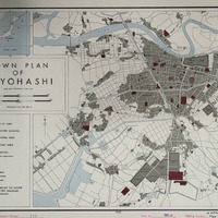
Town Plan of Toyohashi
-
Description
-
eng
The OSS Research and Analysis Branch produced this English US Intelligence map on July 19, 1944. This wartime map depicts a relatively large-scale, detailed urban plan of Toyohashi, a city located on the coast of Japan. Created at the end of World War II, the map was based on an existing Japanese map of Toyohashi from 1927, reflecting military intelligence efforts to document Japanese infrastructure. An inset map in the upper left corner shows Toyohashi’s location in relation to broader East Asia, placing this town in a greater geopolitical setting. In the map legend, a scale is provided which measures distances in both meters and yards. The layout emphasizes strategic urban features through clearly defined legends: built-up areas are shaded in gray, identified buildings and areas are marked in maroon, and military areas are marked with a dark gray border. In labeling facilities, as well as shading in the identified buildings and areas, the map maker makes an effort to highlight important economic, governmental, and community institutions including fish hatcheries, markets, government halls, schools, temples, and the local hospital. Transportation routes are identified separately in the legend as 3’6” gauge railroad, electric railroad, and tramway. Roads are also depicted, as well as bridges, and a ferry route over the Toyokawa River. Water is marked as light blue regions, and the rivers are portrayed in great detail, including the embankments along the Yagyu River at the bottom of the map.
-
Creator/agency who created the original map
-
eng
US Government
-
Date
-
July 19, 1944
-
Genre
-
eng
US Intelligence Maps
-
Contributor
-
eng
Ezra Bernhard, Jerry Shang, Min Wang, Samantha Chan, Zijun Peng, Hiroki Coyle, Dario Rissolo, John Hines-Shah