The "Hyakumanbunnoichi Kōkūzu" is a map collection produced between 1939 and 1944, covering strategic areas in Northeast Asia, including Sakhalin, Primorski Krai, Manchuria, Korea, and central and southern Japan. With a 1:1,000,000 scale (1:1,000,000 kōkūzu), these maps meticulously chart air routes, roads, and urban areas, reflecting the geopolitical importance of the region. Marked "Gokuhi" (confidential) and detailed with contours and spot heights, these maps were essential for strategic planning during East Asia's era of intense modernization and expansion (Cynthia Leng 2024).
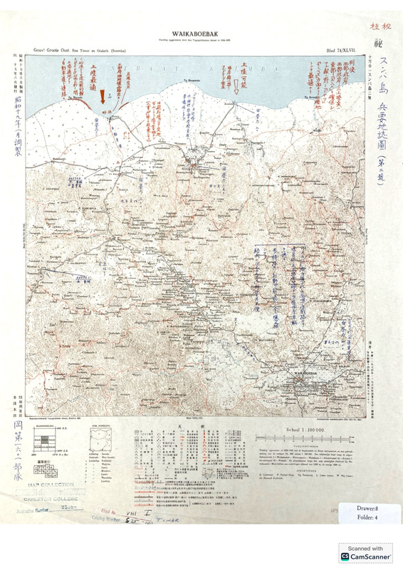
The map is a Japanese intelligence map of Sumba Island (part of the Lesser Sunda archipelago in Eastern Indonesia) during WWII. This is a three-timing map with layers made at three different times. The oldest layer is the base map by the Dutch Colonial Mapping Agency, done based on a 1934-1935 survey. This layer has the outline of the island of Sumba, dense contour lines, rivers, roads, trails and paths, and regions and features labeled in Dutch. The next layer is the Japanese Sixteenth Army reprint of the map from 1942, created when the Japanese invaded the island and captured the Dutch map; the 1942 reprint includes a Japanese title, secrecy classification, and a translated legend. The third layer of the map is another Japanese reprint from 1944 which has extensive notes about Japan’s troop placements, potential enemy landing sites, and other military information. This overlay includes handwritten notes in blue ink (information crucial to the occupation) and red ink (possible future enemy movements). The secrecy classification was also increased in 1944 to “top military secret”. We especially note the historical context that Japan was considering invading Australia, which is fairly close to the Sumba Island. Additionally, by 1944 the United States had begun its “Island Hopping” campaign and were capturing key Japanese-controlled islands to disrupt Japanese sea routes and push towards the Japanese mainland. The map depicts potential landing spots for the enemy, indicating that the army which revised this map may have believed Sumba to be a potential target for the Allies.
The Japanese Land and Survey Department adapted this gaihozu map from a Dutch Colonial Topographic Mapping Agency map in 1942 and 1944. The original Dutch map was produced in color and printed in 1930. This map is the 9th sheet of a 13 sheet map series for Sumba Island. Scaled from 1:100000, the map is categorized as a “three-timing map” as the cartography visually depicts the changes made during Dutch and Japanese control. Both Dutch and Japanese languages are present. Between 1942 and 1944 the military classification of the map was upgraded from secret to top secret. The original Dutch publication contains labels of land areas/bodies of water in Dutch, water shaded in blue, and topographic contour lines to represent the elevations of different areas. The first Japanese overlay published in 1942 details more specific topographic information with an added legend depicting symbols for roads, pedestrian routes, rivers, land features, etc. One of the specifically emphasized symbols of this edition is the road traced with a thick red line, running East/West, identified by the legend as spanning 2-4 meters in width. This road was likely marked as an important transportation route. The modified 1944 version includes blue and red annotations to illustrate Japanese and enemy movements, respectively. Among these annotations is information in red about possible enemy landing sites and a note saying that an airport would be difficult to build and require a lot of effort due to the area being covered by wetlands.