The "Hyakumanbunnoichi Kōkūzu" is a map collection produced between 1939 and 1944, covering strategic areas in Northeast Asia, including Sakhalin, Primorski Krai, Manchuria, Korea, and central and southern Japan. With a 1:1,000,000 scale (1:1,000,000 kōkūzu), these maps meticulously chart air routes, roads, and urban areas, reflecting the geopolitical importance of the region. Marked "Gokuhi" (confidential) and detailed with contours and spot heights, these maps were essential for strategic planning during East Asia's era of intense modernization and expansion (Cynthia Leng 2024).
The "Hyakumanbunnoichi Kōkūzu" is a map collection produced between 1939 and 1944, covering strategic areas in Northeast Asia, including Sakhalin, Primorski Krai, Manchuria, Korea, and central and southern Japan. With a 1:1,000,000 scale, these maps meticulously chart air routes, roads, and urban areas, reflecting the geopolitical importance of the region. Marked "Gokuhi" (confidential) and detailed with contours and spot heights, these maps were essential for strategic planning during East Asia's era of intense modernization and expansion (Cynthia Leng 2024).
One side of sheet consists of a pictorial map and a resource guide (repie-chart) showcase the agricultural, mineral, forest and industrial resources found in North Manchuria.
The other side consists of six black and white photographs, a railway network map of Manchuria and some detailed information on rail and boat travel such as fares and service frequencies.
This map of Edo, titled Saihan Shinkai Oedo Ezu, was published and distributed to the public between 1818 and 1829 by Nichimura Soichi. Unlike most modern maps, its orientation is unconventional: North is to the right, South to the left, and West appears at the top. Three merchant ships are present in Tokyo Bay in the southeast, as well as ports in the bay and bridges over the Arakawa River. The legend shows distances from Nihonbashi in the center to multiple shrines and temples. It also shows the hierarchy of the city by defining symbols for residents from different social classes. At the center of the map is a large blank area marked with the Tokugawa crest, symbolizing Edo Castle. Various symbols across the map indicate the locations of samurai residences, revealing their distribution throughout the city. The most prominent samurai residences are marked by a crest, while other residences are marked by a circle or a square. Notably, a concentration of samurai families is found in the western part of Edo. This cartographic spatial arrangement reflects the hierarchical structure of the city, with the samurai and elite classes residing in the West, or the High City, Yamanote, while merchants and traders were primarily located in the East, or the Low City, Shitamachi. Despite its emphasis on residency, this map was primarily used by travelers who were visiting Edo. The map’s key points out the location of several temples across the city, which were seen as cultural hubs and places for festivities and entertainment.
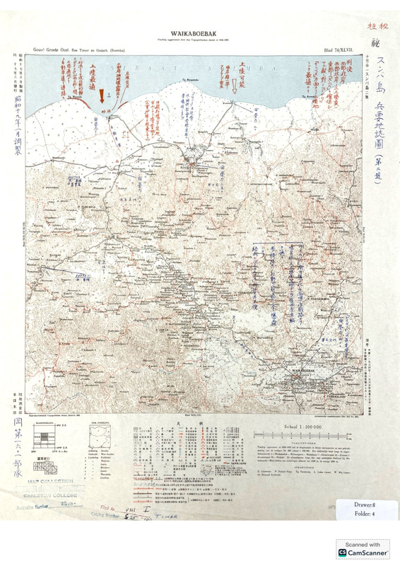
The map is a Japanese intelligence map of Sumba Island (part of the Lesser Sunda archipelago in Eastern Indonesia) during WWII. This is a three-timing map with layers made at three different times. The oldest layer is the base map by the Dutch Colonial Mapping Agency, done based on a 1934-1935 survey. This layer has the outline of the island of Sumba, dense contour lines, rivers, roads, trails and paths, and regions and features labeled in Dutch. The next layer is the Japanese Sixteenth Army reprint of the map from 1942, created when the Japanese invaded the island and captured the Dutch map; the 1942 reprint includes a Japanese title, secrecy classification, and a translated legend. The third layer of the map is another Japanese reprint from 1944 which has extensive notes about Japan’s troop placements, potential enemy landing sites, and other military information. This overlay includes handwritten notes in blue ink (information crucial to the occupation) and red ink (possible future enemy movements). The secrecy classification was also increased in 1944 to “top military secret”. We especially note the historical context that Japan was considering invading Australia, which is fairly close to the Sumba Island. Additionally, by 1944 the United States had begun its “Island Hopping” campaign and were capturing key Japanese-controlled islands to disrupt Japanese sea routes and push towards the Japanese mainland. The map depicts potential landing spots for the enemy, indicating that the army which revised this map may have believed Sumba to be a potential target for the Allies.