
Genre: Premodern Maps
- Title
- en Genre: Premodern Maps
- Description
- en Gould Library has a growing collection of premodern Japanese maps in Special Collections. We currently have about 8 sheets of these maps, and are planning to acquire more. In the context of Japan, the term "pre-modern" usually refers to the period before the Meiji era (1868–1912). Our maps are from the Edo era (1600–1868).
- Creator
- en N/A
- Date
- 1600
- 1868
- Format
- en N/A
Items
-
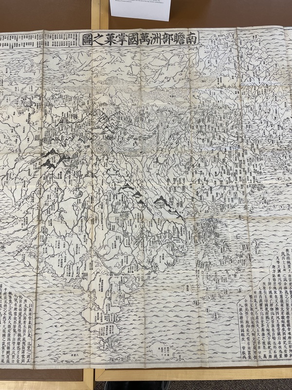 EXAMPLE: Nansenbushū bankoku shōka no zuFirst edition of one of the earliest Japanese printed maps depicting the world. Created by the scholar monk of the Kegon school, Hōtan (1659–1738), the map describes the traditional Buddhist worldview, but also including Europe represented as a group of islands (Iceland, England, Holland, Scandinavia, Poland, Hungary, and Turkey) and South America (shown as an island just south of Japan in the lower right). At the center of the Buddhist cosmos is Mt. Sumeru, surrounded by four continents. Of the four, the Southern continent (“Nansenbushū” as in the title of the map; Sanskrit: Jambudvīpa) is the locus of human existence.
 -
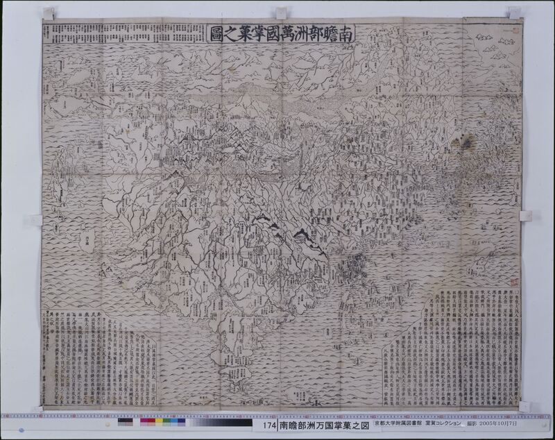 Nansenbushū bankoku shōka no zuThis map was originally wood block printed in 1710 was made by the Kegon monk Hōtan and published by Bundaiken Uhei. It describes the world based on Buddhist literature from India and China and was the first Japanese printed map to depict Europe, North America, and South America through a Buddhist perspective. Near the center of the map are four animal heads with the four great rivers in Buddhist cosmology coming out of their mouths in a spiral. The oval-shaped continent depicting modern-day India and China, Nansenbushū, is said to be the locus of human existence. Although India is still the biggest country in this map, Japan is added and is depicted as bigger than it actually is. In previous manuscript maps of the Buddhist worldview based on Xuanzang’s pilgrimage, depictions of Japan were typically much more simplified and smaller. Perhaps the map maker wanted Japan to be seen as more important in the Buddhist world than it had been before and thus depicted it in this way. Additionally, even though the map does depict Europe, North America, and South America, it makes an effort to keep them on the periphery of the map, which keeps the focus on a more traditional Buddhist cosmology. Interestingly, there are also some clearly fictional islands, like the land of the people with holes in their chests and the land of western women, which may suggest an effort to ignore certain information from existing world maps.
 -
 Saihan Shinkai Oedo EzuThis map of Edo, titled Saihan Shinkai Oedo Ezu, was published and distributed to the public between 1818 and 1829 by Nichimura Soichi. Unlike most modern maps, its orientation is unconventional: North is to the right, South to the left, and West appears at the top. Three merchant ships are present in Tokyo Bay in the southeast, as well as ports in the bay and bridges over the Arakawa River. The legend shows distances from Nihonbashi in the center to multiple shrines and temples. It also shows the hierarchy of the city by defining symbols for residents from different social classes. At the center of the map is a large blank area marked with the Tokugawa crest, symbolizing Edo Castle. Various symbols across the map indicate the locations of samurai residences, revealing their distribution throughout the city. The most prominent samurai residences are marked by a crest, while other residences are marked by a circle or a square. Notably, a concentration of samurai families is found in the western part of Edo. This cartographic spatial arrangement reflects the hierarchical structure of the city, with the samurai and elite classes residing in the West, or the High City, Yamanote, while merchants and traders were primarily located in the East, or the Low City, Shitamachi. Despite its emphasis on residency, this map was primarily used by travelers who were visiting Edo. The map’s key points out the location of several temples across the city, which were seen as cultural hubs and places for festivities and entertainment.