Nansenbushū bankoku shōka no zu
Item
-
Title
-
Nansenbushū bankoku shōka no zu
-
Alternative Title
-
南瞻部洲万国掌菓之図
-
Description
-
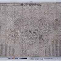
This map was originally wood block printed in 1710 was made by the Kegon monk Hōtan and published by Bundaiken Uhei. It describes the world based on Buddhist literature from India and China and was the first Japanese printed map to depict Europe, North America, and South America through a Buddhist perspective. Near the center of the map are four animal heads with the four great rivers in Buddhist cosmology coming out of their mouths in a spiral. The oval-shaped continent depicting modern-day India and China, Nansenbushū, is said to be the locus of human existence. Although India is still the biggest country in this map, Japan is added and is depicted as bigger than it actually is. In previous manuscript maps of the Buddhist worldview based on Xuanzang’s pilgrimage, depictions of Japan were typically much more simplified and smaller. Perhaps the map maker wanted Japan to be seen as more important in the Buddhist world than it had been before and thus depicted it in this way. Additionally, even though the map does depict Europe, North America, and South America, it makes an effort to keep them on the periphery of the map, which keeps the focus on a more traditional Buddhist cosmology. Interestingly, there are also some clearly fictional islands, like the land of the people with holes in their chests and the land of western women, which may suggest an effort to ignore certain information from existing world maps.
-
Date
-
1710
-
Places shown in the map
-
India China Japan Europe Russia North America South America
-
Subject
-
Religion Buddhism
-
Contributor
-
Samantha Chan
John Hines-Shah
Cameron Richardson
Maddy Sriver
Alejo Enriquez-Lynd