Sunbatō heiyō chishizu
Item
-
Title
-
Sunbatō heiyō chishizu
-
Alternative Title
-
Res. Timor en Onderh (Soemba)
-
Description
-
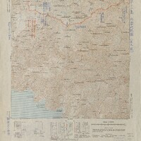
The Japanese Land and Survey Department adapted this gaihozu map from a Dutch Colonial Topographic Mapping Agency map in 1942 and 1944. The original Dutch map was produced in color and printed in 1930. This map is the 9th sheet of a 13 sheet map series for Sumba Island. Scaled from 1:100000, the map is categorized as a “three-timing map” as the cartography visually depicts the changes made during Dutch and Japanese control. Both Dutch and Japanese languages are present. Between 1942 and 1944 the military classification of the map was upgraded from secret to top secret. The original Dutch publication contains labels of land areas/bodies of water in Dutch, water shaded in blue, and topographic contour lines to represent the elevations of different areas. The first Japanese overlay published in 1942 details more specific topographic information with an added legend depicting symbols for roads, pedestrian routes, rivers, land features, etc. One of the specifically emphasized symbols of this edition is the road traced with a thick red line, running East/West, identified by the legend as spanning 2-4 meters in width. This road was likely marked as an important transportation route. The modified 1944 version includes blue and red annotations to illustrate Japanese and enemy movements, respectively. Among these annotations is information in red about possible enemy landing sites and a note saying that an airport would be difficult to build and require a lot of effort due to the area being covered by wetlands.
-
Date
-
1944
-
Places shown in the map
-
Sumba
-
Map Set
-
Sunbatō heiyō chishizu, no. 9
-
Subject
-
Military
-
Contributor
-
Ezra Bernhard
Samantha Chan
Hiroki Coyle
John Hines-Shah
Zijun Peng
Dario Rissolo
Jerry Shang
Min Wang